Croatian Islands
Škoji - The Croatian Islands
Tovarnjak (Zut) Island
Tovarnjak (Zut) Island Info
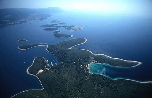
Tovarnjak (Zut) is an unpopulated island with total area of 75628 square meters (m2). The lenght of its coastline is 1315 meters. There is no public transport to Tovarnjak (Zut).| GPS Latitude | 43.87889500 |
|---|---|
| GPS Longitude | 15.33556200 |
| Area(M2) | 75628 |
| Coastline Lenght(M) | 1315 |
Tovarnjak (Zut) GPS coordinates
GPS location coordinates: 43°52'44.0"N 15°20'8.0"ESome Lighthouses in vicinity of Tovarnjak (Zut):
- Babac Lighthouse in Islet Babac near Pasman Island in Pasman Channel at a distance of 6.13 miles.
- Sestrica vela (Tajer) Lighthouse in Dugi Otok Island at a distance of 6.73 miles.
- Prisnjak Lighthouse in Islet Prisnjak near Murter at a distance of 11.72 miles.
- Ostri Rat Lighthouse in Zadar at a distance of 18.53 miles.
- Blitvenica Lighthouse in Islet Blitvenica near Žirje at a distance of 21.19 miles.
- Tri Sestrice (Rivanj) Lighthouse in Rivanj Island at a distance of 25.85 miles.
- Jadrija Lighthouse in Srima at a distance of 27.85 miles.
Marinas in vicinity of Tovarnjak (Zut):
- ACI Marina Zut at a distance of 2.52 miles.
- Marina Sangulin (Biograd na Moru) at a distance of 6.72 miles.
- Marina Kornati at a distance of 6.89 miles.
- ACI Marina Piskera at a distance of 8.21 miles.
- D-Marin Dalmacija (Marina Sukostan) at a distance of 12.11 miles.
Neighbouring islands to Tovarnjak (Zut):
- Gustac near Zut Island at 0.50 miles away.
- Zut Island at 1.45 miles away.
- Gangarol Island at 1.74 miles away.
- Svrsata Mala Island at 1.96 miles away.
- Scitna Island at 2.35 miles away.
- Svrsata Vela Island at 3.05 miles away.
- Kosara Island at 3.35 miles away.
- Skala Mala Island at 3.72 miles away.
- Zutska Aba Island at 3.86 miles away.
- Sit Island at 3.89 miles away.
Nearest Campsites to Tovarnjak (Zut):
- Brist Campsite is at distance of 4.99 miles
- Sovinje Campsite is at distance of 5.39 miles
- Biograd Campsite is at distance of 6.83 miles
- Park Soline Campsite is at distance of 6.90 miles
- Diana & Josip Campsite is at distance of 6.90 miles
Tovarnjak (Zut) Nearby Hotels:
- Vila Rosa in Tkon at a distance of 5.02 miles
- Apartments Melita in Barotul, otok Pasman at a distance of 6.06 miles
- Hotel Adriatic in Biograd Na Moru at a distance of 6.64 miles
- Hotel Ilirija in Biograd na Moru at a distance of 6.64 miles
- Hotel Kornati in Biograd na Moru at a distance of 6.66 miles
- Apartments Vedrana in Biograd at a distance of 6.73 miles


