Croatian Islands
Škoji - The Croatian Islands
Majsan Island
Majsan island Info
The population on the island is 0 inhabitants with total area on the island 152773 square meters. The population density is 0 inhabitants per square kilometer. The hightest peak on the island is meters. The island is accessible by public transport (ferries).More information:
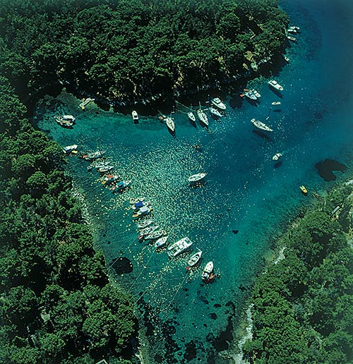
Majsan was inhabited since prehistoric times until the Middle Ages. There is an early Christian church on the Majsan from the 5th century. These early buildings / ruins are still visible on the western coast of the islet. Remains proving that there was life here from ancient Greek times to the early Middle Ages can also be seen on the other islets of this group. In 1000 year, Venetian doge Petar II Orseolo lead his conquest of the south Dalmatian archipelago and the town of Dubrovnik from Majsan.
| GPS Latitude | 42.95889100 |
|---|---|
| GPS Longitude | 17.19264900 |
| Population | 0 |
| Area(M2) | 152773 |
| Coastline Lenght(M) | 1736 |
| Highest peak | |
| Population density | 0 |
Majsan GPS coordinates
GPS location coordinates: 42°57'32.0"N 17°11'33.5"ESome Lighthouses in vicinity of Majsan:
- Sestrica vela (Korcula) Lighthouse in Islet Vela Sestrica near Korcula at a distance of 0.81 miles.
- Sucuraj Lighthouse in Sućuraj, Hvar Island at a distance of 11.47 miles.
- Glavat Lighthouse in Islet Glavat near Lastovo at a distance of 13.55 miles.
- Plocica Lighthouse in Islet Plocica near Korcula at a distance of 19.63 miles.
- Struga Lighthouse in Skrivena Luka, Lastovo Island at a distance of 22.49 miles.
- Sveti Petar Lighthouse in Makarska at a distance of 24.98 miles.
- Sveti Nikola Lighthouse in Pucisca, Brac island at a distance of 36.12 miles.
Marinas in vicinity of Majsan:
- ACI Marina Korcula at a distance of 2.83 miles.
- Marina Solitudo (Lastovo) at a distance of 23.09 miles.
- Marina Ramova ( Baska Voda) at a distance of 27.35 miles.
- Marina Baska Voda at a distance of 30.19 miles.
- ACI Marina Vrboska (Hvar) at a distance of 30.21 miles.
Neighbouring islands to Majsan:
- Majsanic Island at 0.19 miles away.
- Mala Stupa Island at 0.30 miles away.
- Vela Stupa Island at 0.36 miles away.
- Gojak Island at 0.48 miles away.
- Vela Sestrica (Korcula) Island at 0.81 miles away.
- Mala Sestrica (Korcula) Island at 0.94 miles away.
- Rogacic Island at 1.10 miles away.
- Lucnjak Island at 1.13 miles away.
- Skrpinjak Island at 1.14 miles away.
- Sutvara Island at 1.29 miles away.
Nearest Campsites to Majsan:
- Trstenica Campsite is at distance of 1.21 miles
- Glavna plaza Campsite is at distance of 1.28 miles
- Nevio Campsite is at distance of 1.59 miles
- Paradiso Campsite is at distance of 2.03 miles
- Ponta Campsite is at distance of 2.04 miles
Majsan Nearby Hotels:
- Apartments Villa Orebic in Orebić at a distance of 1.15 miles
- Boutique Hotel Adriatic in Orebić at a distance of 1.19 miles
- Apartments Cale in Orebic at a distance of 1.27 miles
- Apartmani Posejdon in Orebić at a distance of 1.28 miles
- Apartments Lada in Orebic at a distance of 1.29 miles
- Apartments Kati in Orebić at a distance of 1.29 miles
